Enhancing Roads for the Future: A Comprehensive Analysis and Rehabilitation Project
In the world of infrastructure development, ensuring the longevity and safety of roadways is a task of paramount importance.
The primary objective of the project was to analyze the condition of a 2,320-foot road to develop a detailed rehabilitation plan to enhance its structural integrity and functionality. A critical component of this undertaking was the extraction of features within a corridor spanning up to 150 feet, including elements crucial to road design such as lane width, shoulders, and potential obstacles.
Solutions Applied
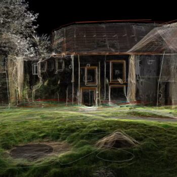
To execute this project with the precision it demanded, we harnessed the capabilities of state-of-the-art technologies and software solutions. Data capture was a fundamental step, specifically LIDAR technology`s ability to provide highly accurate and detailed spatial data.
For the intricate task of corridor extraction and feature analysis, our team relied on TopoDOT, an advanced software designed for processing LIDAR data. Its robust features facilitated the extraction of critical road features within the specified corridor, allowing us to gather crucial insights into lane widths, road shoulders, and various design elements.
To further enhance the project’s scope, Civil 3D, a powerful civil engineering design software, was employed for contour generation. The accurate contours generated by Civil 3D provided us with a comprehensive understanding of the road’s topography, an essential aspect for effective rehabilitation planning.
In a span of 15 hours, our dedicated team meticulously executed the feature extraction, and contour generation processes with breaklines applied. The intricate nature of the project demanded unwavering attention to detail and technical finesse.
Deliverables and Results
The culmination of our efforts was nothing short of remarkable. The project yielded high-precision topographical plans that intricately detailed the road’s features and contours with breaklines applied. The corridor extraction allowed our clients to discern varying lane widths, shoulder conditions, and potential obstacles, providing a comprehensive foundation for the road’s rehabilitation.
At ArenaCAD, we thrive on challenges that drive innovation and progress. The road analysis and rehabilitation project exemplifies our commitment to leveraging cutting-edge technology for the betterment of infrastructure. The fusion of LIDAR data capture, TopoDOT’s feature extraction, and Civil 3D’s contour generation propelled us to deliver results of exceptional accuracy and depth.
As we conclude this project, our sights remain fixed on the horizon of possibility. The road to safer, more robust infrastructure is an ongoing journey, and ArenaCAD is proud to be at the forefront of pioneering solutions that shape the future. Through dedication, expertise, and technological prowess, we’re setting the course for roadways that stand the test of time.
- On August 11, 2023